

Imagine typing “show me every new solar farm built near a river in the last three years” into a chat box — and getting a map full of real satellite photos as the answer. No GIS degree, no expensive software, no scrolling across an entire desert by hand. That is exactly what Planet AI does, and it launched on November 5, 2026. In this beginner-friendly guide, you will learn how to use Planet AI for free, from your first plain-language question to side-by-side change comparisons, timelapses, and scheduled AI reports.
Planet AI is a map-based chat app at ai.planet.com. It lets anyone search more than ten years of Planet’s near-daily satellite imagery using everyday language. Access is free right now, and you do not need any technical skills to start. If you can type a question, you can use it.
Before we begin, one honest note: Planet AI is brand new, and the company has not published accuracy figures for its search. Treat it as a powerful discovery tool, and always verify what it finds by looking at the actual satellite imagery yourself. This guide shows you how to do exactly that.
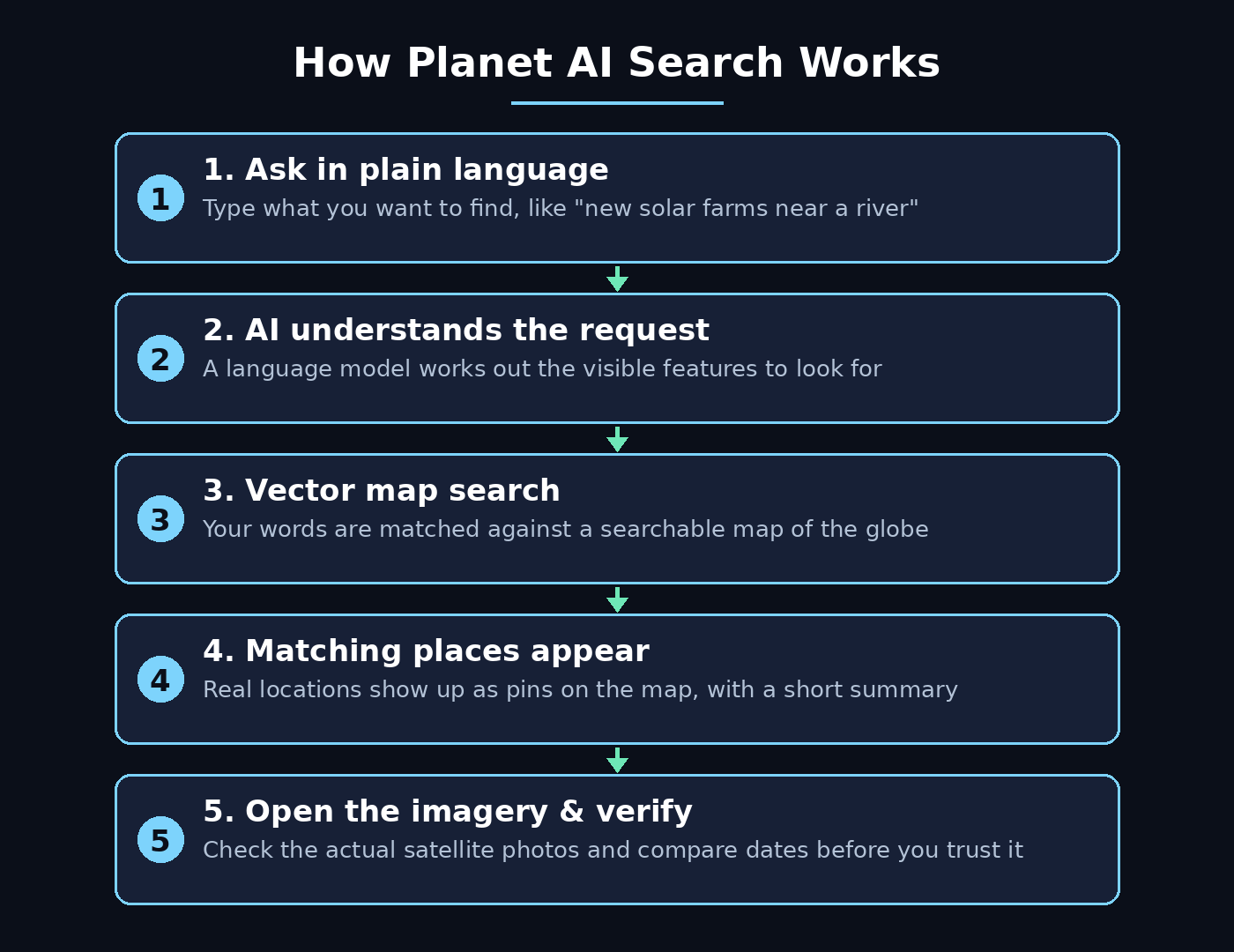
Step 1: Understand What Planet AI Actually Is
Planet AI is not a chatbot that answers from web pages. It is a search engine for the physical world. Planet, the satellite imagery company, photographs the entire landmass of Earth almost every day. The Planet AI app turns that enormous archive into something you can talk to.
Here is how it works in plain terms. Large language models read your question and work out what you are looking for. They then query a searchable vector map of the globe — a map built from AI interpretation of the visual features in Planet’s monthly satellite mosaics. In other words, the imagery has been converted into numeric descriptions of what each patch of ground looks like, and your words are matched against those descriptions. The result is a list of real places, each grounded in satellite imagery you can open and inspect yourself.
Planet frames the app as one step toward what it calls Planetary Intelligence: pairing daily satellite imagery with AI to deliver insights about a changing planet in near real time. The company says today’s AI search is “just the beginning” and plans to bring AI to more of its offerings.
- Search by description: describe what you want to find — a solar farm, a new road, a flooded field — and the AI searches large areas for matching places.
- Change over time: compare the same place across months and years with side-by-side views and timelapses.
- Analyze mode: deploy AI agents that use Deep Research, accept uploaded files, track trends, and send scheduled reports.
- Free to start: access is free right now, with premium capabilities promised later through a Planet Insights account.
It is worth knowing this is not Planet’s first AI product of the year. In September 2026 the company announced Amazon.ia, a tool combining satellite data science and AI for the Amazon rainforest. The Planet AI app is the general-purpose version of that idea, open to anyone.
Step 2: Create Your Free Planet AI Account
Getting started takes only a few minutes, and you do not need a credit card. The app works on desktop and on your phone.
- Go to ai.planet.com in your browser.
- Click sign up and create your account with your email address.
- Sign in with a Planet Insights account if you have one, or create one during signup. Planet says this makes it easier to reach premium capabilities later, though it has not published pricing for them.
- Confirm your email if asked, then open the app. You will see a map with a chat box — that is your whole workspace.
Because the app is only days old, expect the product to change quickly in its first weeks. Treat the official site as the source of truth for pricing and features, and use the “share feedback” button in the main menu if something looks wrong — Planet actively asks for ideas.
Step 3: Ask Your First Plain-Language Question
This is the fun part. Instead of learning GIS software, you simply describe what you want to find. The key skill is to ask for something a satellite can actually see.
Good first questions look like this:
- “Show me large solar farms built in the last three years.”
- “Find new housing developments near rivers in Texas.”
- “Where has forest been cleared in this region since 2020?”
- “Show me airports with long runways in the desert.”
Weak questions ask for abstract ideas a camera cannot see — “illegal activity,” “pollution,” or “poverty.” A satellite sees bare ground, new roads, standing water, and large rooftops, not concepts. Translate your idea into a visible feature before you type it, and your results will be far better.
Type your question into the chat box, press enter, and watch the map. The AI searches the archive and returns matching places as pins or highlighted areas on the map, usually with a short written summary of what it found and why each result matched.
Step 4: Read and Check Your Search Results
Never trust the AI’s summary alone. Planet itself says every result is grounded in imagery you can inspect to verify what the AI finds, and that is the correct way to use the tool. A language model can sound sure while being wrong — the pixels are the proof.
Work through your results like this:
- Scan the top results fast. Discard obvious misses and keep a short list of promising candidates.
- Open the imagery behind each candidate. Zoom in and judge the pixels, not the model’s wording. Does the place really show what you asked for?
- Check the date. Make sure the imagery is from the period you care about, not an old mosaic.
- Rule out seasonal effects. Snow, crop cycles, and dry seasons can all look like change when they are not.
If you run a digital agency or advise clients on locations, this verification habit is what turns a neat demo into a trustworthy deliverable. A screenshot of the satellite image, with its date attached, is evidence; an AI sentence alone is not.
Step 5: Compare Places Over Time with Side-by-Side Views
Finding a place is only half the story. The real power of Planet AI is showing how a place changed. Because the app can reach more than ten years of Planet data, it can search back in time to identify what changed and when.
To compare a location over time, open a result and switch to the comparison view. Pick two dates — for example, January 2021 and January 2026 — and the app shows the same patch of ground side by side. Look for new buildings, cleared land, new roads, water appearing or disappearing, and vegetation growing back.
This is genuinely useful for everyday questions. A farmer can check whether a field was irrigated last season. A journalist can verify when construction started on a site. A conservation team can compare time series to track vegetation recovery and isolate comparable baseline habitats. Planet’s early beta users used exactly these comparisons to monitor large habitats, spot illegal encroachment or fire threats, and verify automated deforestation alerts with imagery before sending field patrols.
Step 6: Build a Timelapse of Any Location
A timelapse turns a slow change into a story you can watch in seconds. Once you have a location open, choose the timelapse option and set your date range. The app stitches the monthly mosaics into a short animation showing the place evolving year by year.
Timelapses are especially good for:
- Urban growth: watch a neighbourhood appear where farmland used to be.
- Environmental change: see a lake shrink, a forest thin out, or a coastline shift.
- Construction projects: show a client or an audience how a site developed from bare ground to a finished building.
- Presentations: a 10-second timelapse explains change faster than ten paragraphs.
Save or share the timelapse when you have one you like. Keep the dates in the file name or caption so anyone who sees it later knows exactly which period it covers.
Step 7: Use Analyze Mode for Deeper Research
Search finds places. Analyze mode investigates them. For deeper work, Planet AI can automatically deploy agents to do complex analysis using Deep Research — the same pattern you may know from general chat tools, except here the evidence is satellite imagery rather than web pages.
Use Analyze mode when your question has several steps. For example: “Find industrial sites near waterways in this county, rank them by proximity to the river, and summarize what changed at each one in the last two years.” The agent breaks the job down, runs the searches, and returns a structured answer with imagery attached to each claim.
Planet highlights environmental compliance as an early use case here. Teams used AI-enabled search to locate and prioritize industrial sites across whole counties by proximity to waterways, and Planet says workflows that took days of manual GIS scanning can now surface high-priority inspection targets in minutes. Those are Planet’s descriptions of early use, not independent measurements — but the workflow itself is real, and you can try it on any region you care about.
If your work involves AI automation services or agentic workflows, Analyze mode is a good example of the pattern in action: a plain-language goal, an agent that plans the steps, and evidence you can check at the end.
Step 8: Upload Your Own Files to Enrich the Analysis
Planet AI does not only work with its own archive. You can upload external files — such as images or CSV spreadsheets — to enrich an analysis. A CSV of site coordinates, a list of addresses, or a reference photo can all become part of the investigation.
Try it like this:
- Prepare a simple CSV with the places you care about — one location per row, with latitude and longitude if you have them.
- Upload it inside Analyze mode and tell the AI what the file contains.
- Ask the agent to check each location in the satellite archive and report what changed.
- Open the imagery for the most interesting rows and verify them yourself before you act on the results.
This turns Planet AI from a search box into a small research assistant. A property researcher can screen dozens of plots in an afternoon. A teacher can build a lesson around real places students know. A small business owner can check a shortlist of sites without hiring a GIS specialist.
Step 9: Track Changes with Trends and Scheduled Reports
Some questions are not one-off searches — they need watching. Planet AI lets you track trends regularly and set up scheduled reporting, so the app checks your area of interest on a schedule and tells you when something changes.
Set up tracking when you have a place or a pattern that matters over weeks or months:
- Monitor a construction site and get a report when new structures appear.
- Watch a forest edge for new clearing, and get alerted early.
- Track water levels in a reservoir across the dry season.
- Follow a competitor’s new facility as it takes shape.
Start with one tracked area and a weekly report. Read two or three reports before you trust the rhythm — you will quickly learn which alerts are real change and which are clouds, shadows, or seasonal shifts. That calibration is the difference between a useful monitoring system and a noisy inbox.
Step 10: Save, Share and Export Your Findings
Good research is useless if nobody can reproduce it. Every time Planet AI gives you a useful result, save it properly: the snapshot, the date range, the question you asked, and the link back to the imagery.
A simple routine works for journalists, analysts, and conservation teams alike:
- Save snapshots with dates so a colleague can reproduce the finding.
- Write down the exact question you asked — the same words can return different results as the app improves.
- Corroborate elsewhere before drawing a conclusion: check public records, field reports, or a second imagery source.
- Share the timelapse or comparison image, not just your summary, so your audience can see the evidence too.
Remember the limits. Planet publishes no accuracy figures, search runs on monthly mosaics (so very short-lived events may need the underlying daily imagery), and pricing beyond the free period is still unknown. Treat findings as leads for verification, not conclusions — and when you verify them, they become genuinely strong evidence.
Planet AI vs Other Ways to Explore Satellite Imagery
Planet AI is not the only way to look at Earth from above. Here is how it compares with the alternatives a beginner might consider.
| Approach | Strength | Trade-off | Best for |
|---|---|---|---|
| Planet AI app | Chat search over a proprietary, near-daily archive; no GIS training needed | Hosted product; pricing beyond the free period unknown | Beginners who want fast answers |
| Google Earth AI | Reasoning agent across Google Earth data | Different data and access model | Google Earth users and researchers |
| Open embedding releases (OlmoEarth) | Open data you can build on | You build the interface and pipeline yourself | Developers and researchers |
| Traditional GIS software | Precise, scriptable, auditable | Needs training and time | Professional analysts |
The honest takeaway: if you want to find places and understand change without learning a new profession, Planet AI is the most direct route in November 2026. If you need survey-grade precision or a fully auditable pipeline, traditional GIS still wins — and the two can work together, with Planet AI doing the fast discovery and GIS doing the careful measurement.
Frequently Asked Questions About Planet AI
Is Planet AI really free?
Right now access is free, according to Planet. The company says signing in with a Planet Insights account makes it easier to reach premium capabilities in the future, but it has not published pricing for them. Check the pricing page inside your account before you commit to a paid plan, because launch pricing can change.
What is the Planet AI app?
It is a map-based chat app from Planet, launched November 5, 2026, that lets users search ten years of Planet satellite imagery in everyday language, explore how sites changed over time, and add public information for context. Planet says no GIS expertise is needed.
How does the app find places from a text description?
Planet says large language models interpret the request and then query a searchable vector map of the globe built from AI interpretation of visual features in its monthly mosaics. Results are grounded in Planet imagery that users can inspect to verify what the AI found.
What can the app do beyond search?
Planet lists change-over-time investigation with side-by-side comparisons and timelapses, and an Analyze mode that deploys agents using Deep Research, accepts uploaded images or CSV files, tracks trends, and sets up scheduled reports.
Who tested Planet AI before launch?
Hundreds of users tried an early version over the summer of 2026, per Planet. Many used it during the discovery phase of their work, to decide where to search or start analysis. Early uses included conservation monitoring and environmental compliance screening.
What are the limits of Planet AI?
Planet describes it as a discovery tool and says AI-enabled search is just the beginning. Results should be checked against the imagery itself, and the company has not published accuracy figures, so treat findings as leads for verification, not conclusions. Search runs on monthly mosaics, so very short-lived events may need the underlying daily imagery.
Final Thoughts
Planet AI changes who gets to ask questions about the planet. Until now, searching ten years of satellite imagery meant GIS software, training, and patience. Now it means typing a sentence. That is a genuine shift — and it arrives at a moment when the questions are urgent, from deforestation and flooding to urban growth and water supply.
Use it the smart way. Ask for visible features, not abstract ideas. Open the imagery behind every result. Compare dates, rule out seasons, and corroborate before you conclude. Save your snapshots with dates so your work can be checked. Do that, and a free app becomes a serious research tool in your pocket.
Try it today: open ai.planet.com, ask one question about a place you know well, and check the answer against what you already know. That first test — on familiar ground — will teach you faster than any guide how much to trust the tool, and where it shines.
Explore More Free AI Tools
Want to keep exploring? Try our free tools: AI Title Generator, Meta Description Generator, AI Rewriter, and Keyword Density Checker — all free on AI Tool Steps.